Sarek 2017: Preview & Preparation

After enjoying hiking the Padjalantaleden last year, I’m heading far up north in Sweden once again. Apart from some minor issues all went pretty well last year.
I’m currently working on writing a report about the 2016 trip.
I’ll try to finalise the Dutch version before my departure, but I’m not sure if I’ll have enough time for it.

In less than two weeks I’m starting what will most likely be the most challenging journey of my life. I must say I’m really looking forward to it and I’m pretty excited already.
At the same time I must admit I’m a bit anxious aswell.
On the menu is a 12 day trip through the national parks Störa Sjofallet and Sarek.
I’ll be covering well over 160 kilometers and 3.500 metres in elevation.
That is assuming I don’t stray from my route or get lost offcourse 😉
Both national parks are part of the Laponia area, which is protected by UNESCO and is part of it’s World Heritage List.
Laponia is home to the Sami people, one of the last few people on earth with an ancestral way of life, based on the seasonal movement of livestock.
Most of the Sami settlements are in Padjelanta though.
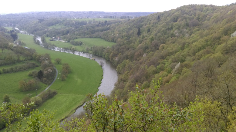
The landscape in Störa Sjofallet and Sarek is rough and has gigantic proportions.
Turbulent streams have carved valleys through the many 2000+ metre peaks.
Boulder fields, snow, river crossings, swampy terrain,… will make this trip a legit outdoor challenge.
With glacial sediment feeding the rivers, the views on the river delta’s in Sarek are quite exceptional.
Sarek especially has quite the reputation for the possibility of very foul weather and harsh conditions. It is sometimes called the “European Alaska”.
This may be a bit of an exaggeration, but it is a very remote place indeed.

Obviously at this time I’m in full-preparation-mode.
I’m real busy fine-tuning and gathering my gear, defining the route, looking for possible camp sites, …
Also a big difference compared to last year’s hike is that in Sarek there are no marked trails or anything like it. Apart from the construction of some essential summer bridges, nothing is done here to accommodate hikers.
There is one small hut with an emergy phone, but that is basicly it.
Navigation will be an essential part of the trip and obviously there is also no cell phone coverage.

I’ve had some advice from a fellow hiker who lives nearby and decided to buy a satelite phone.
The Delorme Inreach SE costed me around €270 but I think going alone it is an essential tool.

Inreach

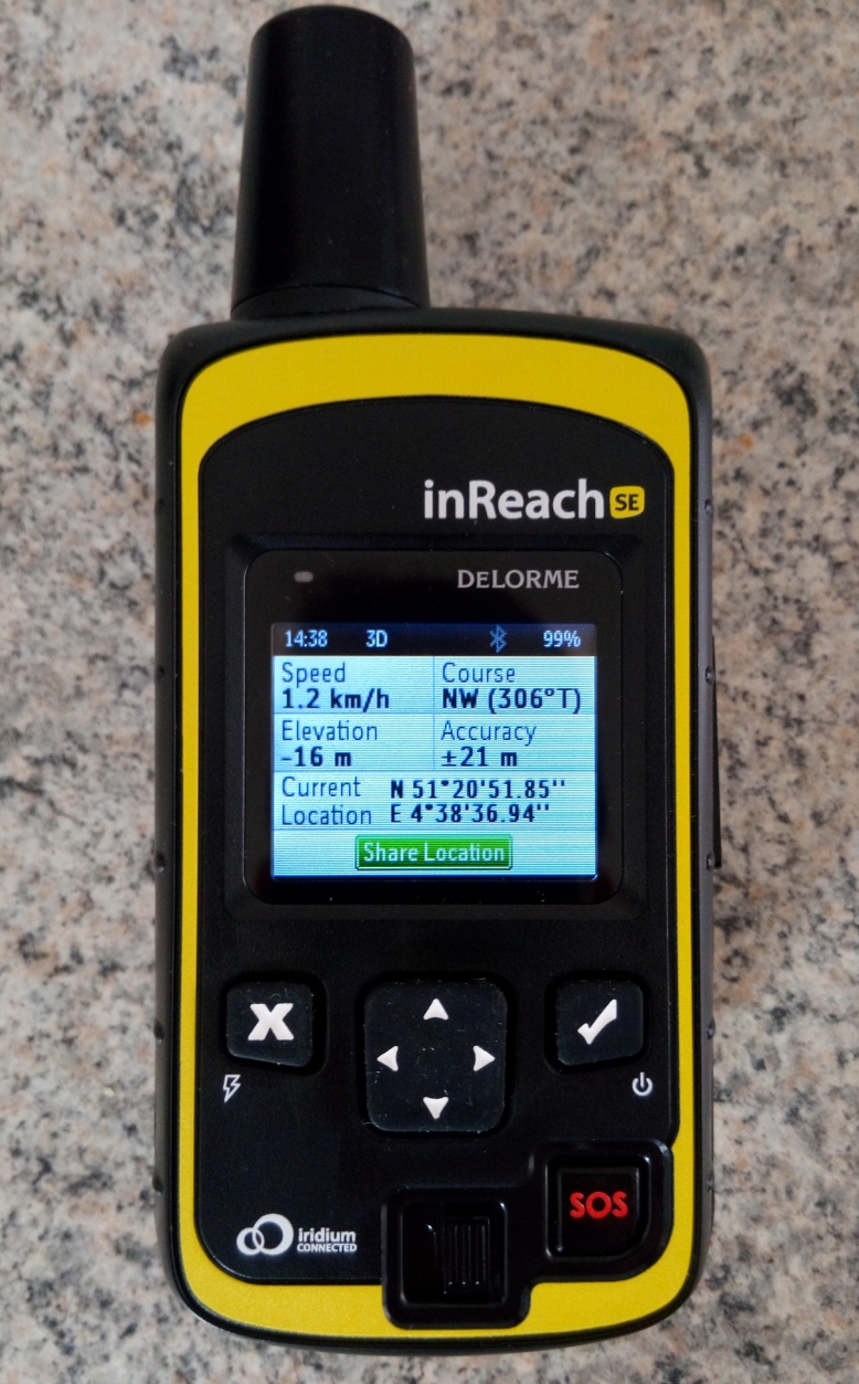
With my Inreach I’m able to send messages to family members and send an SOS signal in the case of an emergency.
It is not really designed as a GPS, but it can however provide current coordinates.
I will be mostly relying on my map and compass, but having coordinates definitely is very helpful.

Now let’s take a brief look at the route I’m planning. The next two maps show the entire route, apart from the last 40 kilometres.

map_sarek_1

map_sarek_2

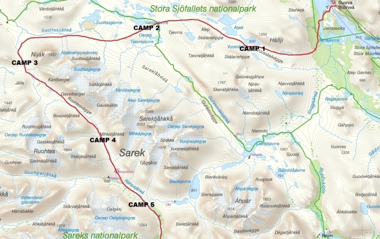
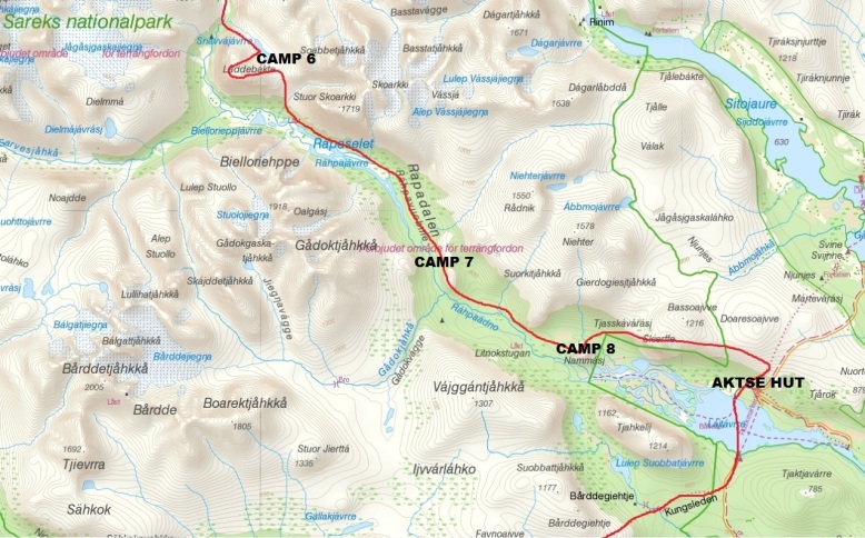
The journey starts at Suorva, where I’ll be crossing the dam.
This is forbidden in theory, but in Sweden people have common sense…
Through the fence there is a small gate that is left open for hikers 🙂
Immediately I have to climb up 500 metres in elevation and head west.
Walking around the remarkable Nijak peak, I’ll be entering the valleys of Sarek.

The final 40 kilometres which are not shown I’ll be hiking on the Kungsleden (“King’s trail”).
This is probably the most popular long-distance hike in Sweden.
This trail is both marked and less demanding.

There’s tons of stuff to tell about the entire route, but I’m not gonna go into too much detail now. I am however especially looking forward to climbing Laddebakte (1537m) and Skierffe (1179m). Both peaks offer incredible views over the Rapa valley and river.

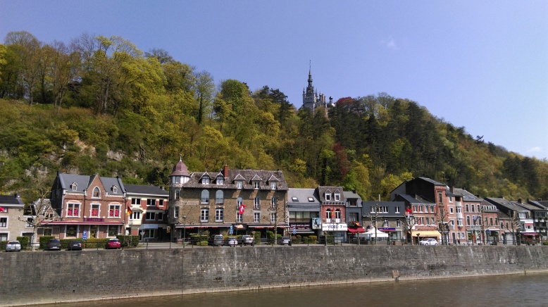
I’ll be ending my trip in the mountain station of Kvikkjokk where a warm bed and excellent restaurant will await me 🙂 You couldn’t really call Kvikkjokk a village though, as only 11 people permanently reside there!

In my opinion gathering information is key to a succesful hiking trip.
it is 2017 and even this high up north social media is finding it’s way.
There are a few Facebook pages from nearby mountain stations and helicopter companies that provide very usefull updates.
On one of these pages I found some recent pictures.
The following picture was taken on June 29th in Ruotesvágge.
This is the valley I should reach on day 4.
So on the map it is situated between “CAMP3” and “CAMP4”.

Ruotesvágge_29_06_2017

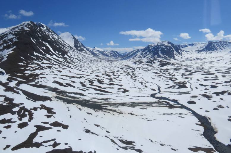
As you can see there is still a lot of snow. It is however melting fast these days.
But still I’m a bit worried about high water levels.
Getting your feet wet at times is pretty normal in Sarek, but I hope it’s not gonna be too much to handle. I’ll surely carry a few extra pair of socks 😉
I’m also still a bit undecided about my choice of footwear.
I have a solid pair of mountain boots (B-type), but recently I bought a pair of trailrunners which I really like a lot. I think both options have plusses and minusses.
For the river crossings I’ll probably be wearing an old pair of running shoes again.

For now I have to stop typing and get some stuff sorted out.
Thanks again to Ivo VM for the advice!
I’m now gonna try out the tent that you handmade.
Hopefully you guys have enjoyed the read.
Feel free to contact me for any questions you might have.

Cheers
Kevin

Day Trip Around The Ourthe Oriental (Houffalize)

With my trip to Sweden rapidly approaching, I decided to go to the Ardennes once again.
Looking for an interesting hike I found plenty of inspiration at “Originele Wandelingen”
This site features about 150 different day hikes around Belgium.
Sadly the descriptions are only available in Dutch, but GPS tracks are available for most hikes.
Each hike is graded from one to five.
A while ago I found out the hard way that hikes with the highest rating are not to be underestimated.
After some consideration I picked a 16K hike called “De Oostelijke Ourthe”.
It’s rated four out of five which I think is pretty fair.

Description in Dutch
GPS Tracks

For weeks and weeks the weather has been miserable but sun is finally shining as I drive towards Filly, a small township in Houffalize.
Two hours later I arrive in the picturesque village, but can’t really find a proper place to park my car. Eventually I leave my car at a parking strip next to Rue de Houffalize.

Parking

The red dot obviously indicates the starting point

The hike starts off at the lowest point in Filly, next to a small shack and a meadow filled with sheep. Right of the bat there’s plenty of mud, so obviously you should be wearing decent boots and clothes that you don’t mind getting dirty.
After walking along meadows for a bit there’s a first short but tough climb.

IMAG1863

Briefly you walk on a bit of a plateau surrounded by meadows.
You can also spot some beautiful poppies here.

IMAG1866

Not only in Flanders fields!

Pretty quickly a steep descent towards the river is a first test for my knees.
On and off I have been dealing with sore knees. I’m likely suffering from Plica syndrome.
A couple days of rest and lots of ice has usually done the trick, but sometimes you just have to ignore the pain 🙂

When you get to the river the trail starts to become a bit adventurous.
The massive rainfall from previous days obviously still had it’s impact and the path is very narrow at times. Frequently you also have to make your way around, over or under dead trees.

IMAG1873

After about one kilometre along the river you reach a small bridge and you have to get to the other side. Now you follow the river upstream.
Once again the path is filled with quite some obstacles.
At times the trail is further away from the river and in general I found the hike to be very varied.

At waypoint 82 there is a highly recommended spot for taking a break.
Over here there is a pretty large wooden picnic table, but more importantly there’s a cliff which offers an amazing view. I really enjoyed my cold pasta meal here!

IMAG1894

Nice view for lunch!

When you get going again it’s pretty steep downhill towards the bungalow park “Camping Rensiwez“. A bit further ahead you have to walk on tarmac for a few 100 metres.
When you head into the forest again, you walk alongside a beautiful stream called “Ruisseau de Martin Moulin“. This part was really muddy. I also spotted some fishermen here.
At a certain point another stream “Ruisseau de Belle Meuse” flows into the Martin Moulin stream. At this point you just keep on going straight ahead.

IMAG1904

After about another kilometre you have to cross the stream.
At the designated point there is a really crappy “bridge”.

IMAG1906
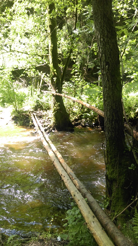
But a couple 100 metres earlier there is a very decent one.
Alternatively you can also choose to keep on following the stream for another 500 metres or so and then you will reach “Achouffe“, a small village famous for it’s beer called “La Chouffe“.

lachouffe_maina_2

Like to taste a local beer? It’s only a 1K detour!

I opted to just follow the standard route. Bearing in mind that I also have to cross a couple streams/rivers in Sweden I decided to do the same here.
Besides the water would only get up until my knees.
With my knife I sharpened a branch in order to have better stability while crossing.
Everything went fine, but I did found out that it is very easy to underestimate a river’s current…
Off course my boots and socks were soaking wet now.
I stopped to squeeze out as much moisture as I could and walked on.
Now you in fact walk back to the crossing of streams.
When you reach the crossing again, there’s a short but very tough climb.

IMAG1908

I needed a breather after this climb!

In just a few minutes you’ll be on a plateau, about 60 metres up from the stream.
At this point I took another break.
While letting my socks and boots dry out some more I enjoyed a handful of pinda nuts.
In the next part of the route the forest gets a bit more dense and you’ll also spot several interesting rock formations.

IMAG1907

While in general the trail description is pretty good, at this point I found it to be very confusing at times. So if you are not an expert in navigation I would strongly recommend to bring along a GPS device with the tracks. Personally I have an app called GPX viewer installed on my smartphone, which you can download for free and works just perfectly.

The next few kilometres there’s still plenty of up- and downhill sections and also some very nice views. Eventually you reach a concrete bridge called “Pont de Pierre“.
Over here you have to make a right and the road now leads you up to a township called “Petite Mormont“. At this point it’s only another 2,8 kilometres until the end of the hike.
The last 100 metres you walk between two meadows and the trail is really narrow.
More importantly all the grass and the vegetation easily reaches up to about a metre and a half! So if you have a machete or something it can be useful.
Off course a branch or a walking pole can also do the trick.
The road you’ll see ahead of you now is the Rue de Houffalize.

It’s around 17.30 as I jump into my car again.
I’m not that keen on driving another 185 kilometres.
Luckily in the Ardennes region you can hit the throttle without having to worry much about speeding tickets 🙂

Back home I take a shower, eat some more pasta and… fall asleep on the couch.
My knees hurt but luckily the next day I’m not feeling any pain any more.
All in all this is a very beautiful hike and it’s also been good preparation for my trip to Sweden.

Have any questions about this hike? Feel free to ask!

Day hike in the Belgian Ardennes (Esneux)

Sunday May 1. It’s 4.30 in the morning and I hop into my car.
Heading of for Esneux, a small town in the Belgian Ardennes.
I haven’t done a lot of hiking so far this year and I need to start preparing for my trip to Sweden in June. I’ve been looking at different routes on the web and have selected one of the toughest I could find. Turned out to be a bit overambitious to say the least.
It’s almost 6.00 am when I park my car near the bridge in the small, charming village.
I have no map, but I have GPS-tracks on my smartphone. Another blunder there!

The first few kilometres aren’t that tough.
The route (Le Grand Site de la Boucle de l’Ourthe) starts of going through a nice park.
Although pretty fast it turns out that the navigation isn’t that easy. Even with GPS coordinates…
After about 45 minutes I spot a fox in the park.
I wasn’t paying much attention as suddenly I saw him just a couple meters in front of me.
He clearly didn’t see me coming too, as it looked like I gave the poor fellow a bit of a scare.
In a instant he took off and crossed a shallow river and climbed up a slope.
After a while I passed another small village and then the route took me through several fields.

IMAG1655

Steadily I made my way through all the high grass and over barbed wire.
Slowly it started to dawn on me that this was no ordinary hike.
Next thing I spot a warning sign indicating a difficult passage, especially in wet conditions.
Luckily, it isn’t raining, but it had been raining a lot in prior days.
The trail gets pretty narrow and is packed with rocks.
Some parts are really muddy and I slip a couple times, but manage to regain my balance just in time. I’m getting a bit tired already, but decide to push on.
I wanted to complete the 19km by noon…

After reaching the river Ourthe the trail really starts to get tough.
Navigation is again a bit unclear, so I decide to follow some markings.
Another sign “côte de la mort” warns for the steep inclination. Slowly I work my way up.
At the top I notice I’m 30 something meters off from the GPS.
I realize I have to work my way down again.
At this point the slope is about 70% and carefully I work my way down.
On hands and feet, hanging on to stumps and rocks.
I feel relieved as it was a bit of a scary descent.
I follow the GPS for another 300 meters or so as I notice I in fact have to climb back up …
Clearly I should have read the description of the trail in advance.
There is a bit of a ditch leading my way up to the ‘Roche-aux-Faucons’, but still it is really, really tough.

Collage_ABCD

Every other minute I have to take a small break.
When I finally reach the top, the views are well worth it.

3

I take a couple of pictures, drink some water and walk on.
The trail is still going up and down all the time, but nothing too crazy any more.
Another issue is that the battery of my smartphone is getting low and I can’t check the GPS as often as I would like to.
A couple kilometres further I’m walking through a bit of a ditch and I have to make a right.
But there isn’t even the slightest sign of a trail. I decide to take a bit of a shortcut.
My knees start to hurt. The rest of the hike still brings some nice views, but I decide to not overdo it and skip another loop. At around 1.30 pm I finally reach my car again.
Dead tired and with my clothes covered in dirt I drive home.

4

A shower and a power nap later I’m feeling okay again. I reward myself with a big pack of French fries. It has been a good workout and I’ve learned a lot from the mistakes I made.
Until the next episode!